 by
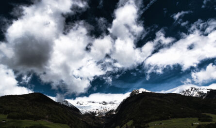
by Often referred to as the “Queen of the Mountains,” Mount Rigi rises gracefully above the shimmering waters of Lake Lucerne and Lake Zug. Its panoramic viewpoints, accessible hiking trails, and historic railways make it one of Switzerland’s most visited alpine destinations. While the scenery may feel timeless, the way travelers explore it has evolved dramatically—thanks to modern mobile apps.
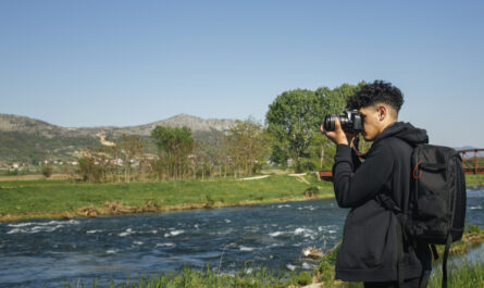
Today, a well-prepared visitor doesn’t just rely on guidebooks or printed maps. Instead, smartphones have become essential companions, offering real-time navigation, weather insights, transport coordination, and even interactive learning experiences. When used wisely, the right apps can transform a good trip into a seamless and deeply rewarding one.
This guide explores the most useful apps for visiting Mount Rigi and explains how they can enhance every stage of your journey—from planning to exploration.
Why Mobile Apps Are Essential for Mount Rigi
At first glance, Mount Rigi might seem straightforward to explore. It is well-connected by public transport and features clearly marked trails. However, like any alpine environment, it presents a few challenges:
- Weather conditions can change rapidly
- Trails vary in difficulty and elevation
- Transport connections may involve multiple steps
- Certain areas may have limited connectivity
Mobile apps help bridge these gaps by providing accurate, up-to-date, and location-specific information. Whether you’re navigating a trail or checking train schedules, having reliable digital tools ensures that your trip remains smooth and stress-free.
Navigation and Trail Apps
swisstopo – Precision Mapping at Its Best
For anyone planning to hike on Mount Rigi, swisstopo is one of the most dependable tools available. Created by Switzerland’s official mapping authority, it offers highly detailed topographic maps that are tailored specifically to the country’s terrain.
What sets this app apart is its accuracy. You can see elevation contours, terrain features, and official hiking routes with remarkable clarity. Even better, you can download maps for offline use—an essential feature in areas with weak signal.
This app is particularly useful for travelers who want to explore beyond the main viewpoints and venture onto less crowded trails.
SwitzerlandMobility – Curated Scenic Routes
If you prefer structured hiking experiences, SwitzerlandMobility is an excellent companion. It provides access to a wide network of officially designated trails across the country, including several around Mount Rigi.
Each route comes with detailed information such as duration, elevation gain, and highlights along the way. This makes it easier to choose a hike that matches your fitness level and interests.
Unlike generic navigation apps, SwitzerlandMobility focuses on quality over quantity, ensuring that every route you follow is safe, well-maintained, and visually rewarding.
Komoot – Personalized Exploration
Komoot adds a more flexible, user-driven approach to navigation. It allows you to plan custom routes based on your preferences, whether you’re looking for a leisurely walk or a challenging hike.
The app also includes voice navigation and community-generated recommendations, which can help you discover hidden gems that might not appear in official guides.
For travelers who enjoy a bit of spontaneity, Komoot offers the freedom to explore Mount Rigi on your own terms.
AllTrails – Real User Insights
AllTrails is particularly useful for gathering real-world feedback. Before committing to a trail, you can read reviews from other hikers, view photos, and check recent updates on trail conditions.
This can be especially helpful if you’re unsure about difficulty levels or want to avoid crowded routes. The app’s GPS tracking feature also allows you to monitor your progress during the hike.
Transportation Apps
SBB Mobile – Seamless Travel Planning
Reaching Mount Rigi typically involves a combination of trains, boats, and cable cars. The SBB Mobile app simplifies this process by bringing everything into one place.
With real-time updates, platform information, and ticket purchasing options, it eliminates the uncertainty that can come with navigating unfamiliar transport systems.
For example, you can easily plan a journey that includes a scenic boat ride across Lake Lucerne followed by a cogwheel train ascent—without needing multiple tickets or schedules.
Weather and Safety Apps
MeteoSwiss – Reliable Forecasts
In the mountains, weather conditions can shift quickly. A clear morning can turn into a foggy or stormy afternoon, which may affect visibility and safety.
MeteoSwiss provides highly localized forecasts, including hourly updates and weather warnings. Checking this app before heading out can help you make informed decisions about your plans.
Exploration and Learning Apps
PeakFinder – Interactive Views
One of the most memorable aspects of Mount Rigi is its panoramic scenery. Numerous alpine peaks can be seen extending beyond the horizon on a clear day.
PeakFinder enhances this experience by using augmented reality to identify mountains in real time. Simply point your phone at the landscape, and the app will label each peak with its name and elevation.
This transforms a beautiful view into an educational and interactive moment, deepening your appreciation of the surroundings.
All-in-One Outdoor Apps
Outdooractive – Comprehensive Toolkit
Outdooractive combines several features into a single platform, including route planning, navigation, and points of interest.
It’s particularly useful for travelers who want a streamlined experience without switching between multiple apps. You can find nearby restaurants, viewpoints, and rest stops while also tracking your route.
Optional Fitness Tracking Apps
Strava – Track Your Performance
For those who enjoy monitoring their activity, Strava is a great addition. It allows you to track distance, elevation gain, and pace, turning your hike into a measurable achievement.
While not essential, it can add a sense of accomplishment and motivation—especially if you enjoy setting personal goals.
How to Combine These Apps Effectively
No single app can cover every aspect of your trip. The best approach is to use a combination of tools, each serving a specific purpose:
- Use swisstopo or SwitzerlandMobility for route planning
- Rely on SBB Mobile for transportation logistics
- Check MeteoSwiss for weather updates
- Use PeakFinder to enhance scenic viewpoints
- Add Komoot or AllTrails for additional insights
By combining these apps, you create a well-rounded digital toolkit that supports every stage of your journey.
Practical Tips for Using Apps in the Alps
Prepare for Limited Connectivity
Even on a popular mountain like Mount Rigi, signal strength can vary. Always download maps and routes in advance so you can access them offline.
Carry a Backup Power Source
Cold temperatures and continuous GPS usage can drain your battery quickly. A portable charger ensures that your phone remains functional throughout the day.
Cross-Check Information
While apps are reliable, it’s always wise to verify details using official signs and local guidance. Trail markers and station announcements remain important sources of information.
Avoid Over-Reliance
Apps are tools, not replacements for awareness. Stay mindful of your surroundings and make decisions based on real-time conditions.
Enhancing the Overall Experience
Using apps isn’t just about convenience—it’s about enriching your experience. With the right tools, you can:
- Discover quieter trails away from crowds
- Learn about the geography of the region
- Optimize your time and avoid unnecessary delays
- Travel with greater confidence and safety
In this way, technology becomes a bridge between modern convenience and natural exploration.
The Future of Digital Travel in Alpine Destinations
As technology continues to evolve, travel apps are becoming more sophisticated. Features such as augmented reality navigation, AI-driven recommendations, and real-time hazard alerts are already emerging.
Destinations like Mount Rigi are particularly well-suited to these innovations, as they combine natural beauty with strong infrastructure. In the coming years, visitors can expect even more seamless integration between digital tools and outdoor experiences.
Conclusion
A visit to Mount Rigi is an opportunity to experience the beauty of the Swiss Alps in a way that is both accessible and inspiring. While the landscape itself remains unchanged, the way we explore it has been transformed by technology.
From precise navigation with swisstopo to efficient travel planning via SBB Mobile and interactive learning with PeakFinder, each app adds a new layer of depth to your journey.
By choosing the right combination of tools, you can navigate with confidence, adapt to changing conditions, and fully immerse yourself in everything Mount Rigi has to offer.
In the end, the goal is simple: to spend less time worrying about logistics and more time enjoying the breathtaking views, fresh alpine air, and unforgettable moments that define this remarkable destination.